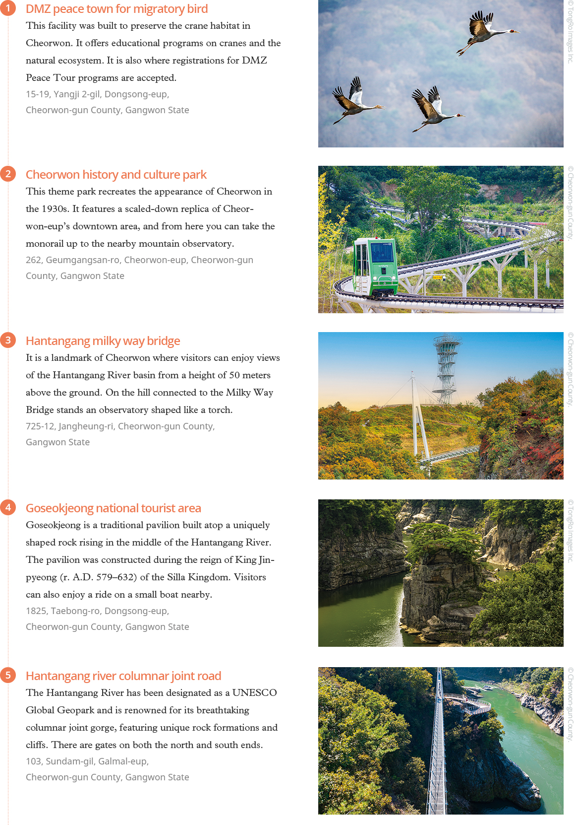
September 2025


On July 27, 1953, a ceasefire was declared three years after the Korean War broke out. Seventy-two years later, Koreans live in a peace hard-won through immense sacrifice. Cheorwon-gun County is where that peace was born—the place that made our daily lives today possible. The echoes of war have faded, but its traces linger in the land. Visiting Cheorwon is not just a journey into history, it is a walk in the footsteps of peace.
Writer. Hye Kyeong Sung
The drive northeast reveals a changing landscape as towering skyscrapers and bustling crowds give way to mountains and rice fields. After two hours, Cheorwon, Gangwon State (Gangwon-do Province) appears.
Cheorwon sits directly across from North Korea, separated only by the Demilitarized Zone (DMZ). This area formed part of the “Iron Triangle” where fierce battles raged during the Korean War (1950-1953). The intense moments fought 75 years ago for everyone’s peace still linger here. Korea’s peace began in this place.
 Baengmagoji (White Horse Hill) was a fierce battlefield during the Korean War. A monument and exhibition hall now honor the fallen and educate future generations about the battle’s significance.
At the DMZ Peace Town in northern Cheorwon, tours of war relics run only four times daily—at 9:30, 10:30, 13:30 and 14:30—with mandatory guides. Despite the early hour, the center bustles with people eager to encounter this unknown world.
Following the escort vehicle leads to the Second Tunnel. This North Korean invasion tunnel was discovered on March 19, 1975. It stretches 3.5 kilometers total and could have moved about 30,000 people per hour. Three exits and a central plaza for gathering large forces reveal its military purpose. Displays show the tunnel’s structure, North Korea’s invasion plans, and recovered artifacts. Seven soldiers who first discovered this place lost their lives—a reminder that the present exists because of such sacrifice.
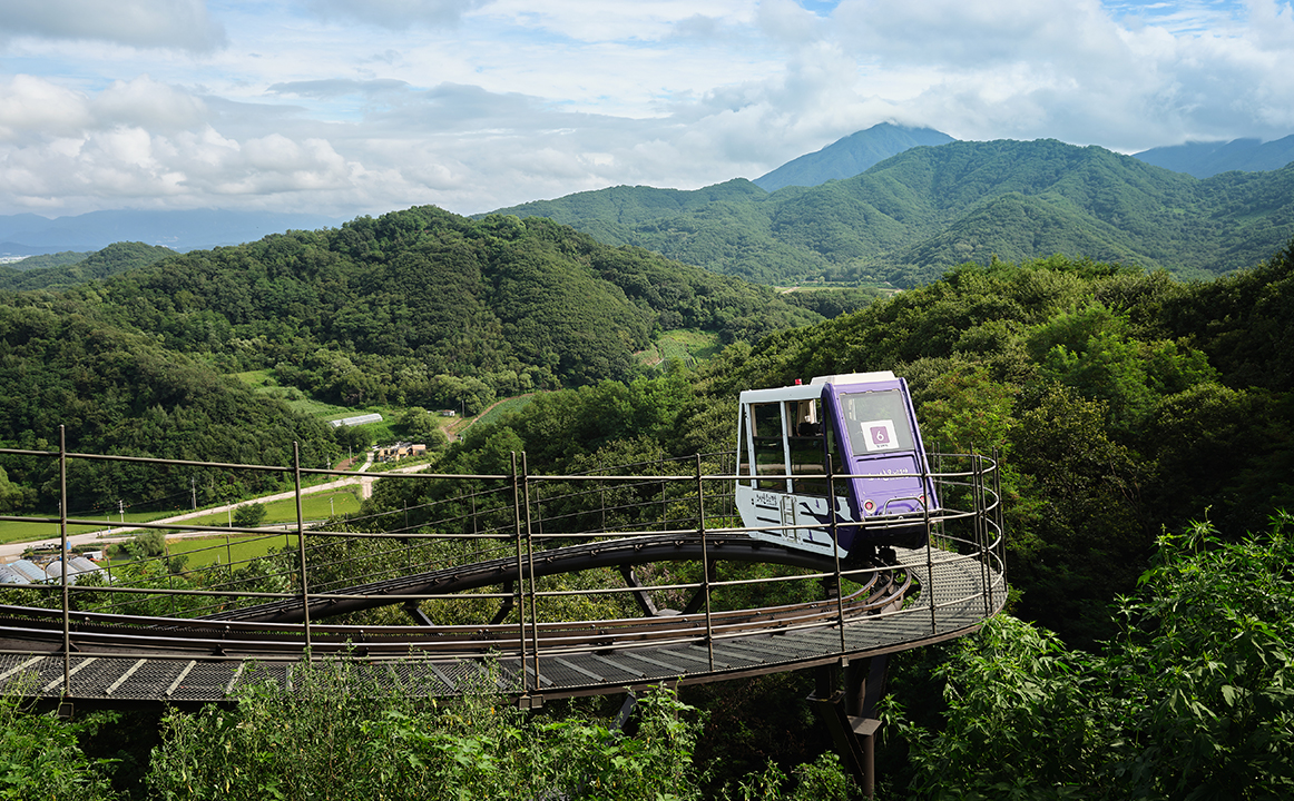 The Cheorwon History Park Observatory, which offers views of Cheorwon’s vast plains and part of the DMZ, can be accessed by monorail.
A land once whole became divided, creating the “Demilitarized Zone” as a buffer. For 72 years, restricted human access has allowed nature to flourish abundantly. The Peace Observatory offers a sweeping view of this transformation. A monorail ride reveals a picture-perfect landscape: lush green forests beneath a breath-takingly clear sky, with mountains visible in the distance. High-precision telescopes reveal North Korean guard posts and villages in the distance. The scene appears endlessly peaceful and refreshing, yet here the Battle of White Horse Hill unfolded—seven rounds of capture and recapture claiming tens of thousands of casualties. This dazzling beauty serves as a symbol of division, with heartbreaking history lying dormant beneath the stunning landscape.
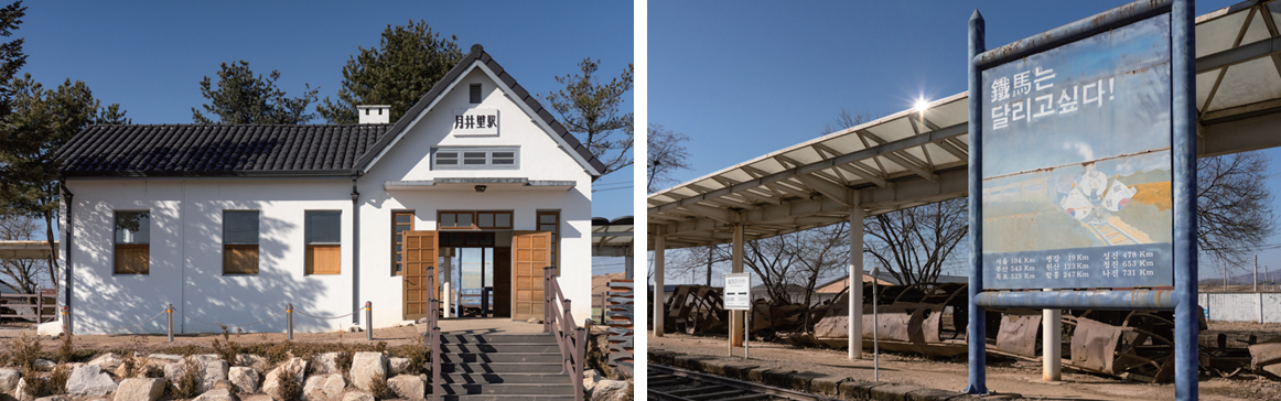 (Left) Woljeong-ri Station on the line connecting Seoul’s Yongsan and North Korea’s Wonsan © Gettyimages Korea.
(Right) In front of Woljeong-ri Station, parts of old trains remain rusted, allowing visitors to feel the pain of war and the passage of time. © Gettyimages Korea.
Woljeong-ri Station stands as another stop where time has frozen. This station once connected Seoul’s Yongsan with North Korea’s Wonsan. A rusted, destroyed train sits silently beside the small country-style platform. A sign reading “The Iron Horse Wants to Run” expresses hopes for reunification. Though stationary and accepting the passing years, the train seems ready to dash forward once these tracks revive. The scene evokes images of trains carrying passengers northward, racing unstoppably along tracks extending to Europe.
The tour concludes at the Korean Workers’ Party Headquarters. Built in 1946 when Cheorwon fell under the rule of communists before the Korean War, this North Korean structure required forced mobilization of residents’ labor and resources. Fierce fighting left it scarred— shells and bullets destroyed the interior and pockmarked the exterior. The ruins evoke countless people and events from those frightening, hopeless times. In this place, now little more than rubble, the tragedy of conflict and division becomes starkly apparent once again.
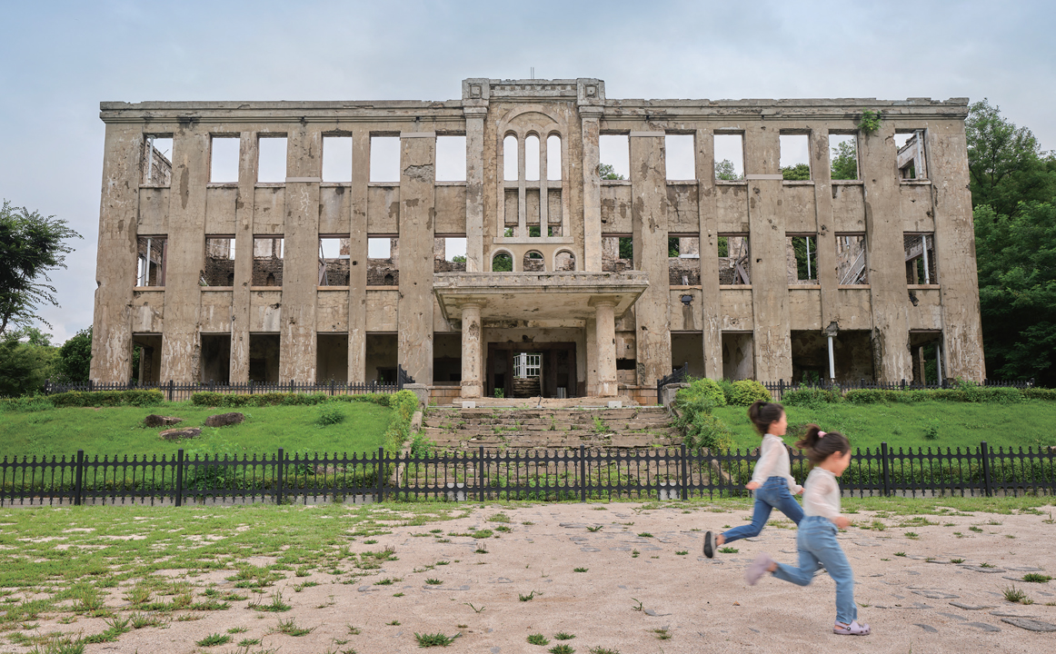 Although the interior has become ruins, the Korean Workers’ Party Headquarters holds historical value and is a National Registered Cultural Heritage.
빼곡한 고층 빌딩, 수많은 사람이 만드는 분주함이 일상인 대도시를 뒤로한 채 자동차에 올라 동북쪽으로 달린다. 건물들의 높이는 점차 낮아지고 산과 논밭이 넓게 펼쳐진다. 2시간을 거쳐 도착한 이곳은 강원도 철원이다.
철원은 비무장지대를 사이에 두고 북한과 맞닿아 있다. 6·25 전쟁 당시 치열한 전투가 벌어졌던 ‘철의 삼각’을 이루는 지역이기도 하다. 이곳에는 지금으로부터 75년 전, 모두의 안녕을 위한 치열했던 순간이 스며있다. 한국의 평화는 여기서 시작됐다.
철원 북쪽의 DMZ 두루미평화센터를 찾았다. 9시 30분, 10시 30분, 13시 30분, 14시 30분, 하루에 4번 해설사와 동행해야만 볼 수 있는 전쟁 유적을 보기 위해서다. 이른 시간임에도 불구하고, 미지의 세계를 만나려는 이들로 센터 안은 북적였다.
접수를 마친 뒤 인솔 차량을 따라 이동하다 제2땅굴에 도착한다. 1975년 3월 19일에 발견된 북한의 남침용 땅굴이다. 총길이는 3.5 km, 1시간에 약 3만 명이 이동할 수 있는 규모다. 출구는 세 개, 굴 가운데에는 대규모 병력이 모일 수 있는 광장도 있다. 내부에 전시된 땅굴의 구조며 북한의 침략 계획, 과거 습득물을 꼼꼼히 살핀다. 이곳을 최초 발견한 군인 7명이 목숨을 잃었다고 했다. 누군가의 희생 위에 내가 있고 지금이 있음을 깨닫는다.
하나였던 땅이 둘로 나뉘었고 비무장지대라는 완충지대가 생겼다. 그곳은 72년간 사람의 발길이 제한됐고, 자연이 무성히 자리를 잡았다. 그 모습을 한눈에 담을 수 있는 평화전망대로 이동한다. 모노레일을 타고 입장한 그곳엔 그림 같은 전경이 기다리고 있었다. 초록이 우거진 숲이며, 숨이 탁 트이는 맑은 하늘, 멀리 산도 보인다. 한없이 평화롭다. 그러나 여기서 일곱 번에 걸쳐 탈환과 재탈환을 반복한 백마고지 전투가 일어나고 수만 명의 사상자가 발생했다. 눈부시게 아름다운 이 모습이 곧 분단의 상징이라니, 발 아래 마음 아픈 역사가 잠들어 있다니 어딘가 씁쓸해진다.
시간이 멈춰버린 월정리역에도 방문한다. 서울 용산과 북한 원산을 잇는 철도선 위의 역이다. 작은 시골집의 분위기를 풍기는 간이역 앞으로 다 부서져 버린 녹슨 열차가 가만히 서 있다. 정차한 채 다가오는 세월을 받아들일 뿐이지만, 이 철로가 살아나는 날이라면 금방이라도 달려 나갈 것만 같다. 사람들을 한가득 태우고 북으로, 유럽으로 이어지는 철로를 거침없이 달려가는 열차를 떠올리며 기대에 부푼다.
종착지로 노동당사를 찾았다. 6·25 전쟁이 발발하기 전, 1946년 철원이 소련 군정 치하에 들어갔을 때 세워진 북한군의 건물이다. 격전 당시 온갖 포탄과 총탄을 맞아 내부는 파괴되고 바깥은 상처투성이다. 먼 옛날 이곳을 스쳐 갔을 수많은 사람과 사건을 그려본다. 두렵고 막막했을 시절이었을 테다. 폐허나 다름없는 이곳에서, 분쟁과 분단의 비극이 다시 한번 여실히 와닿는다.
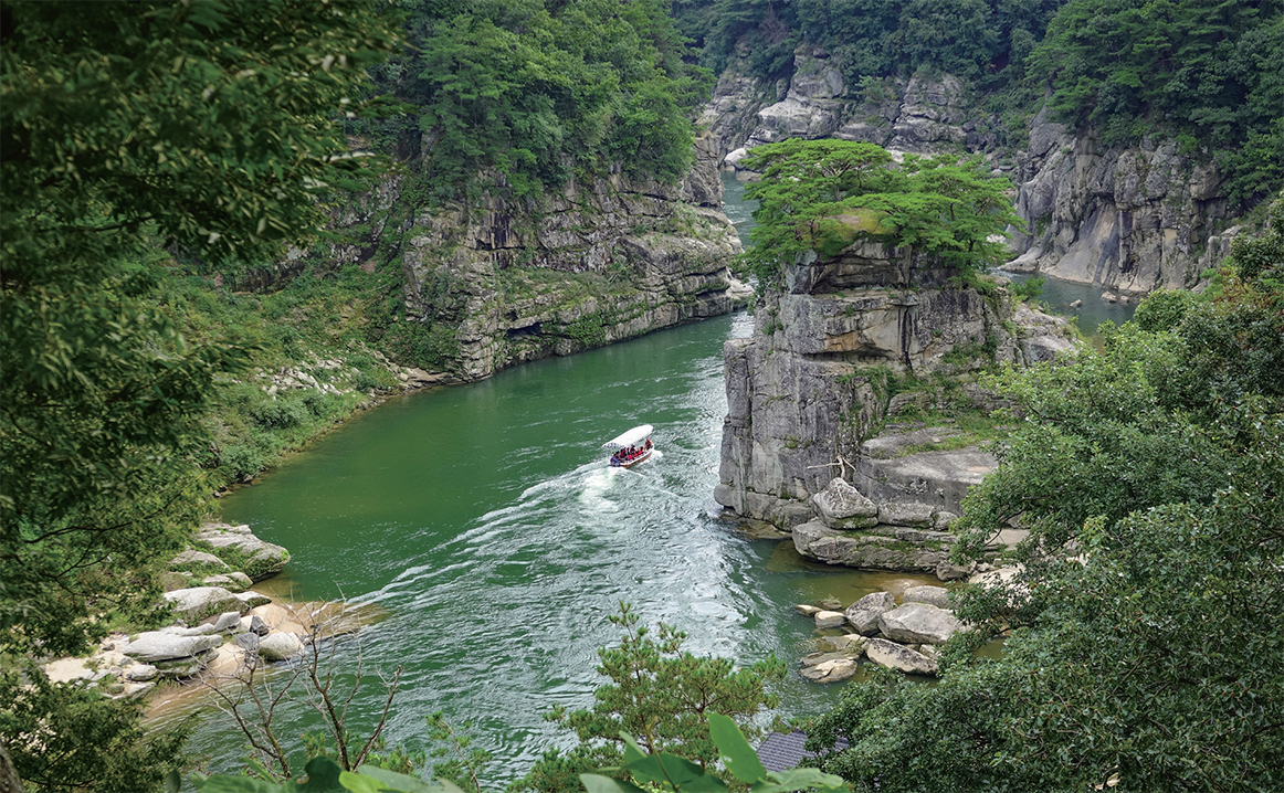
Traveling through Cheorwon while reflecting on the meaning of peace and security, one natural feature consistently catches the eye: Cheorwon’s landscape itself. Most striking of all are the Hantangang River area and its surrounding columnar joints.
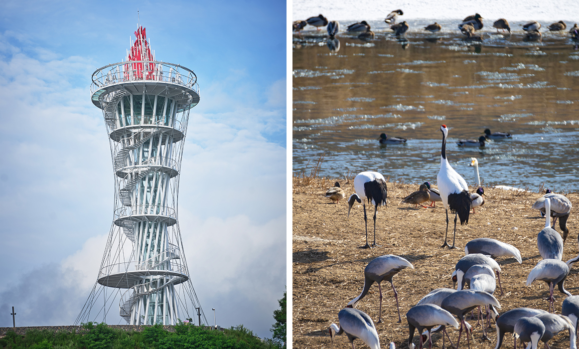 (Left) A torch-shaped observatory in front of Milky Way Bridge in Cheorwon, which spans the Hantangang River
(RIght) Cheorwon is famous for its ecological value, as it is a habitat for migratory birds such as cranes. © TongRo Images Inc.
The Hantangang River embraces waterfalls between cliff walls that rise like sheer precipices, while jade-colored water pools and sparkles beneath the cascading streams. This masterpiece was formed when lava that erupted between 100,000 and 500,000 years ago covered the granite bedrock, then water gradually carved through the layers. The entire 1,165.61 square kilometer area gained recognition as a UNESCO Global Geopark in July 2020.
The journey begins at a restaurant where spectacular scenery serves as the perfect accompaniment to a meal. The Hantangang River area teems with freshwater fish, and the particularly clear water makes local ingredients famously delicious. Among the various regional dishes, megimaeuntang (spicy catfish stew) proves an excellent choice. The spicy broth contains catfish, freshwater shrimp, assorted vegetables and handpulled dough. Unlike firm ocean fish, the catfish’s texture is remarkably tender and sweet.
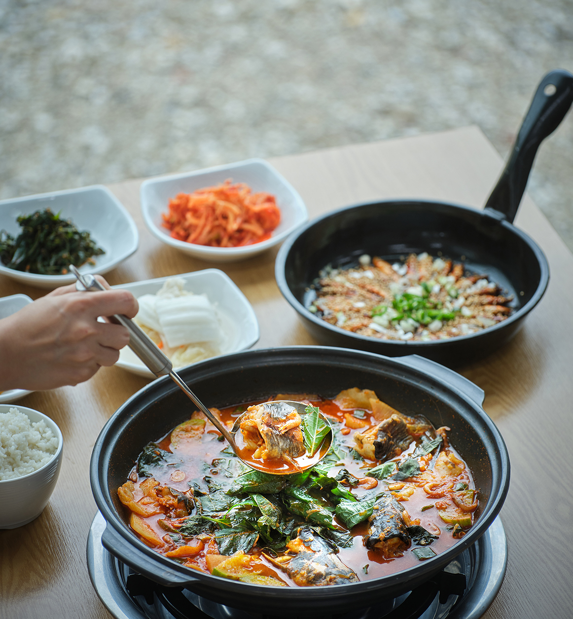 Megimaeuntang (spicy catfish stew), one of Cheorwon’s most popular dishes
After the meal, the route leads to Goseokjeong to appreciate the columnar joints. Originally a Silla Kingdom (57 B.C.-A.D. 935) pavilion built atop rocky cliffs, the name now encompasses the entire surrounding area. From the pavilion, islands rising from the river come into view, with ferry boats gliding gracefully across the water.
Moving south from Goseokjeong reveals walking paths carved between the cliff faces. After purchasing tickets at the booth and descending stairs that connect to the trails, a walking course stretching to another entrance unfolds. Following the cliff-side path leads to sections that seem to extend into the middle of the Hantangang River, creating the sensation of walking on air.
A floating bridge installed directly over the Hantangang River operates in October, inspiring plans to revisit Cheorwon during that season.
Cheorwon serves as a reminder that today’s daily life should never be taken for granted. Tomorrow’s encounters, the people nearby and every aspect of ordinary life approach like gifts. On the journey home, these gifts accumulate carefully in one corner of the heart.
 At Goseokjeong, you can ride a boat and look up at the columnar joints from the water. © Gettyimages Korea.
철원을 누비며 평화나 안보의 의미를 되새기는 동안 내내 눈에 들어온 것이 있다. 철원의 자연이다. 그중에서도 가장 눈여겨 본 것은 철원의 한탄강 일대와 그 주변의 주상절리다.
한탄강은 직벽처럼 솟은 절벽 사이로 폭포를 품고, 떨어지는 물줄기 아래에는 옥빛 물이 고여 반짝인다. 기반암인 화강암 위에, 50만~10만 년 전에 분출한 용암이 그 위를 뒤덮은 후 물이 침식되며 만들어진 작품이다. 1,165.61 ㎢ 일대 전부가 2020년 7월 유네스코 세계지질공원으로 인증되었다.
절경을 반찬 삼아 즐겁게 식사할 수 있는 식당을 방문한다. 한탄강 일대에는 민물고기가 많고, 물이 특히 맑아 재료들이 맛 좋기로 유명하다. 여러 향토 음식 중, 민물고기 중 하나인 메기가 들어간 매운탕을 주문한다. 매콤한 국물에 메기와 민물새우, 각종 채소와 수제비가 들어간다. 메기는 단단한 바다 생선과 달리, 식감이 무척이나 부드럽고 맛 또한 달다. 과연 자연이 선사한 맛이다.
배를 채운 후, 주상절리를 즐기려 고석정을 찾는다. 고석정은 본래 신라시대에 세워졌다고 알려진 기암절벽 위 정자인데, 이제는 정자를 포함해 그 일대 전부를 일컫는 지역명이 되었다. 정자에 오르니 강 위로 솟아있는 섬이며, 물 위를 유유히 떠다니는 나룻배가 눈에 들어온다. 배에 몸을 싣고 강 한가운데에서 절벽을 올려다보며, 그 늠름한 모습을 눈에 담고 수천 년 전 사람들을 상상한다. 그들은 이곳을 아름답게 여겨 정자를 만들고 휴식을 취했다. 그 풍경 앞에서 그들이 느꼈을 감정이 지금의 것과 크게 다르지 않았을 듯하다.
고석정에서 남쪽으로 이동하여 한탄강 절벽에 조성된 산책길을 거니는 호사도 누려본다. 매표소에서 표를 구매한 뒤 산책로와 이어지는 계단을 얼마간 내려가다 보면, 다른 입구로 쭉 이어지는 산책 코스가 펼쳐진다. 아래로 끝없이 뻗는 폭포를 눈에 열심히 담다가도, 때때로 그 높이가 체감되어 아찔함이 느껴지기도 한다. 절벽을 따라 걷다가 강 한가운데로 뻗어나가는 듯한 다리를 밟으니, 공중을 걷는 것만 같다. 완연한 가을에 접어들면, 한탄강 위에 부교가 설치된다고 한다. 그 계절에 철원을 다시 찾을 계획을 세운다.
철원은 지금의 일상이 결코 당연한 것이 아님을 일깨워주었다. 내일 마주할 하루, 곁에 있는 사람들, 평범한 모든 것이 선물처럼 다가온다. 집으로 돌아가는 길, 그 선물을 마음 한편에 차곡차곡 쌓아둔다.